I live in Anchorage and I’m always craving new adventures. One September, when I discovered that there were over 200 miles of road I had not been on in Northwestern Alaska, I grabbed a friend and we hopped a plane to Nome, located in Alaska’s Far North.
Our 3-day road trip began with a 2-hour flight from Anchorage. Nome sits on the shores of the Bering Sea with miles and miles of beach on one side and large sloping mountains on the other. Our flight arrived in the early evening. The sun was setting and a bright rainbow lit up the sky. About 20 muskoxen dotted the stretch of road from the airport to our hotel. We grounded ourselves with a drink at the Gold Dust Saloon.
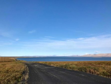
The road from Nome to Teller
The next day we set out for Teller, a native village about 72 miles from Nome. After five minutes of driving on the Teller Highway, you enter complete wilderness. It is not wilderness in the sense of forest and trees. The landscape is open and vast. This region is beyond the tree line – the edge of habitat in the far north where trees are unable to grow. What you see is miles of mountain tundra, lakes, and waterfalls. Rivers look like veins weaving across the vast landscape.
In early September, the mountains on the Seward Peninsula are lit up with vibrant fall colors. I kept taking pictures of the landscape – all the different reds, purples, orange shades of tundra. Rainbows seemed to pop up everywhere. We got out about midway along the drive and walked across a low bridge across the Sinuk River. The water was so clear that you could see schools of spawning salmon swimming below us.
As the highway climbed higher into the mountains, the fog over the ocean lifted and you could see King Island standing alone in the distance. Another rainbow stood before us. We passed musk ox and reindeer as we reached the highest pass in the road. Teller lies at the bottom of the pass in a secluded bay where Imuruk Basin drains into the Bering Sea. A group of little girls smiled and played in the one-lane gravel highway as we made our way into the village. Drying salmon hung from an old fence across the road from a sled dog team. I thought of my friend Michelle whose Inupiat ancestors had herded reindeer here. After a walk along the quiet beach of Teller, we made our way back toward Nome.
We returned to Nome for lunch and then set out toward Safety Sound for the afternoon. The gravel highway parallels the Bering Strait for much of the drive. Remnant of unrelenting storms, massive piles of driftwood lined the beach for miles. The ocean seemed to be calling us. Despite the wind and waves, we got out and walked along the shore looking for beach glass.
The wind was blowing fiercely as we reached Safety Roadhouse, the last check-point on the Iditarod trail. The Roadhouse stood cozy and inviting against the cold back-drop of the storming ocean. We had a warm drink and added our names to the list of Iditarod mushers and other travelers who had been here.
From Safety Roadhouse, the highway rounds a bend toward The Last Train to Nowhere. During the Gold Rush, wealthy Chicago investors sought to connect the region’s major mines by rail. They laid 35 miles of track before the quest for gold folded. Today, rusted out locomotives sit vacant like ghosts. A rainbow, but no gold.
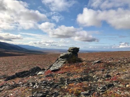
The next day we went to Shangri-La. The Nome-Taylor Highway is one of the most beautiful roads in all of Alaska. There were portions of the drive that reminded me of the road through Denali National Park, snow-capped mountains and river valleys carved out by ancient glaciers.
Salmon Lake stood out like a turquoise jewel against the vibrant tundra. The Bureau of Land Management (BLM) manages a campground here with day-use picnic tables and a boat launch. Exploding with cranberries and blueberries, we spent much of our time hunched over foraging during our stop here.
Cranberries everywhere! Our September trip to Nome
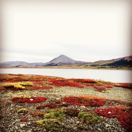
From Salmon Lake we followed the Grand Central River for several miles as we made our way through the Kigluaik Mountains. We could see Mount Osborn – the Seward Peninsula’s tallest peak – in the distance. At the bottom of Golden Gate Pass we took a rugged side-ride toward Pilgrim Hot Springs. This road is not for the faint at heart. Carving its way up and over a mountain, as we crested the top you could see trees in the basin below us. This was Shangri-La. The natural hot springs of the pilgrim river valley create their own unique ecosystem with grassy meadows and tall birch and cottonwood trees.
We were the only people at the hot springs. A private bathhouse for changing sat next to the deep pool with a picnic table and flat rocks to sit on. We stayed here for quite a while taking in the wonder of trees in the Arctic. The soil here is so rich that a consortium of native corporations is now farming produce to distribute to regional elders and schools.
Leaving the hot springs, the late afternoon light fell just right on the mountains. Bright white quartz seemed to burst out of red mountainside. We pulled over and hiked to the top of a peak for a view that did not disappoint. To the west, you could see the Imuruk Basin flowing into the sea where we had been the day before. Miles below us the Kougarok River edged its way through the mountains toward the Bering Land Bridge National Preserve. Everything seemed connected and timeless in that moment.
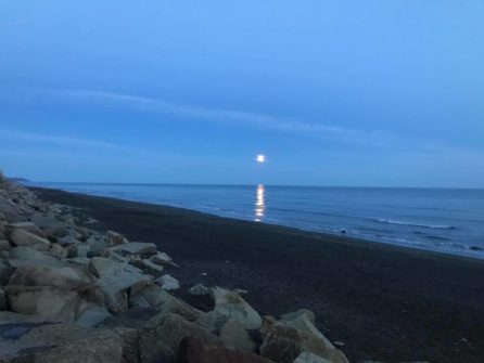
We got back to Nome just before dusk. The Gold Dust Saloon sounded like the perfect place to toast our epic adventure in Nome. I didn’t think the day could get better, but it did. We looked out and the full moon reflected perfectly in the glassy Bering Sea. The ocean was calling one last time. Time to head back out.